Collecting, mapping, and analyzing field data using Web GIS Tools

The value that field experiences bring to education (Carleton College 2010: Fuller 2006; RGS 2005; Louv 2006) includes bridging the divide between the classroom and the “real world”, contextualizing student learning, incorporating multi-disciplinary approaches, conducting real research, using all five senses, social interaction, experience with field data collection methods, tools, and devices, and fostering appreciation for the environment and community issues.
One result of the advent of geographic information systems (GIS) to the web is a set of smartphone apps that allows for the easy collection of environmental field data that can then be mapped and analyzed. The wide variety of qualitative and quantitative information that students gather during field experiences, such as water quality, land use, housing, vegetation, pedestrian counts, noise, weather, types of retail, and much more, can be mapped and analyzed using a web GIS, such as ArcGIS Online. Data can be input via tools ranging from pencil-on-clipboards to field probes, smartphone GPS, mapping and fitness apps, and GPS receivers.
An example of a field data collection application useful for environmental education is Survey123 (https://survey123.arcgis.com/). Survey123 is suited to map trees, birds, weather, historical buildings, or other phenomena on a school campus or nature center. Survey123 for ArcGIS is a simple, intuitive form-centric data gathering solution that makes creating, sharing, and analyzing surveys possible in three steps: (1) Ask questions and plan the survey. (2) Design the survey by dragging and dropping questions with a web-based form or with an Excel spreadsheet. (3) Collect the data into the form using a smartphone.
Once gathered, the survey results can be studied through the resulting ArcGIS Online map, where data can be symbolized, classified, queried, analyzed, and published as a web mapping application such as a multimedia story maps. Analysis tools such as proximity, routing, spatially significant clusters, mean center, overlay, and others can be applied to the data. Additional map layers can be added to the map of survey results, such as geology, soils, zoning, land use, ecoregion, precipitation, population change, and traffic. The survey and map can be shared with a group of students and instructors or the entire school, nature center, or other organization in which students are working. The survey and map can also be shared with the general public, resulting in a truly crowdsourced tool, or one in which people can contribute to in “citizen science” mode.
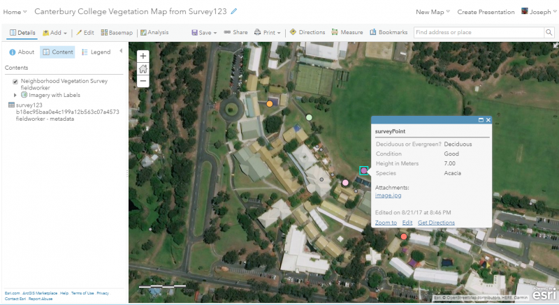
An example of a Survey123 form to gather data on vegetation (Figure 1) was generated using the web-based method. The survey results appear in real time on the resulting map (Figure 2), and the data can be further examined using ArcGIS Online spatial analysis tools.
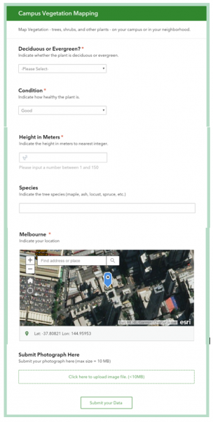
Figure 1. Form created in Survey123 for collecting vegetation on a campus, nature center, or elsewhere in the field. The web form experience is much like the ease of using Google Forms or SurveyMonkey.
These tools are freely available to educators via the Esri Schools program (www.esri.com/schools). With the advent of online open mapped data, powerful yet easy to implement field-based tools, and analysis capabilities, gathering and assessing field data has never been so readily accessible for environmental educators.
References
Carleton College. 2010. The benefits of field instruction. https://serc.carleton.edu/NAGTWorkshops/field/benefits.html
Fuller, Ian C. 2006. What is the value of fieldwork? Answers from New Zealand using two contrasting undergraduate physical geography field trips. New Zealand Geographer. https://onlinelibrary.wiley.com/doi/full/10.1111/j.1745-7939.2006.00072.x
GTAV Fieldwork Resources: https://www.gtav.asn.au/resources/fieldwork-2
Louv, Richard. 2008. Last Child in the Woods: Saving Our Children from Nature-Deficit Disorder. Algonquin Books: 416p. https://www.amazon.com/Last-Child-Woods-Children-Nature-Deficit/dp/15651....
Royal Geographical Society (RGS). 2005. The role and value of fieldwork. https://www.rgs.org/RGS/media/RGS-Media-Library/In%20the%20field/Fieldwo...